
File:1901 Australian federal election.svg

Size of this PNG preview of this SVG file: 512 × 356 pixels. Other resolutions: 320 × 223 pixels | 640 × 445 pixels | 1,024 × 712 pixels | 1,280 × 890 pixels | 2,560 × 1,780 pixels.
Original file (SVG file, nominally 512 × 356 pixels, file size: 1.5 MB)
| This is a file from the Wikimedia Commons. Information from its description page there is shown below. Commons is a freely licensed media file repository. You can help. |
Summary
| Description |
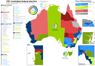
English: 1901 Australian federal election map by electoral division. South Australia and Tasmania did not use electoral divisions for the 1901 election. Boundary data courtesy of "Commonwealth of Australia, 1901-1988, electoral redistributions / produced by the Australian Electoral Commission and the Australian Surveying and Land Information Group, Dept. of Administrative Services ; [Glenn Rhodes, editor ; Ian Duncan, cartographer ; Colin Pennyfield and Eric Syne, computer aided drafting]," and electoral results courtesy of Adam Carr |
| Date | |
| Source | Own work |
| Author | MsCosmicAsh |
Licensing
I, the copyright holder of this work, hereby publish it under the following license:
This file is licensed under the Creative Commons Attribution-Share Alike 4.0 International license.
- You are free:
- to share – to copy, distribute and transmit the work
- to remix – to adapt the work
- Under the following conditions:
- attribution – You must give appropriate credit, provide a link to the license, and indicate if changes were made. You may do so in any reasonable manner, but not in any way that suggests the licensor endorses you or your use.
- share alike – If you remix, transform, or build upon the material, you must distribute your contributions under the same or compatible license as the original.
File history
Click on a date/time to view the file as it appeared at that time.
| Date/Time | Thumbnail | Dimensions | User | Comment | |
|---|---|---|---|---|---|
| current | 13:38, 27 April 2024 | | 512 × 356 (1.5 MB) | MsCosmicAsh | Tasmania unopposed -> 20%+ |
| 13:35, 27 April 2024 |  | 512 × 356 (1.5 MB) | MsCosmicAsh | Updated map, adding seating chart taken from the Victorian Parliament, added vote rings for federal data, SA Statwide and Tas Statewide | |
| 00:19, 5 June 2023 |  | 512 × 356 (930 KB) | MsCosmicAsh | Added seat name chart, labels | |
| 01:42, 1 April 2023 |  | 512 × 412 (390 KB) | MsCosmicAsh | Uploaded own work with UploadWizard |
File usage
The following pages on the English Wikipedia use this file (pages on other projects are not listed):