
File:Śląsk Cieszyński-Polacy 1910.png
Size of this preview: 689 × 600 pixels. Other resolutions: 276 × 240 pixels | 551 × 480 pixels | 882 × 768 pixels | 1,176 × 1,024 pixels | 1,484 × 1,292 pixels.
Original file (1,484 × 1,292 pixels, file size: 394 KB, MIME type: image/png)
| This is a file from the Wikimedia Commons. Information from its description page there is shown below. Commons is a freely licensed media file repository. You can help. |
Summary
| Description |
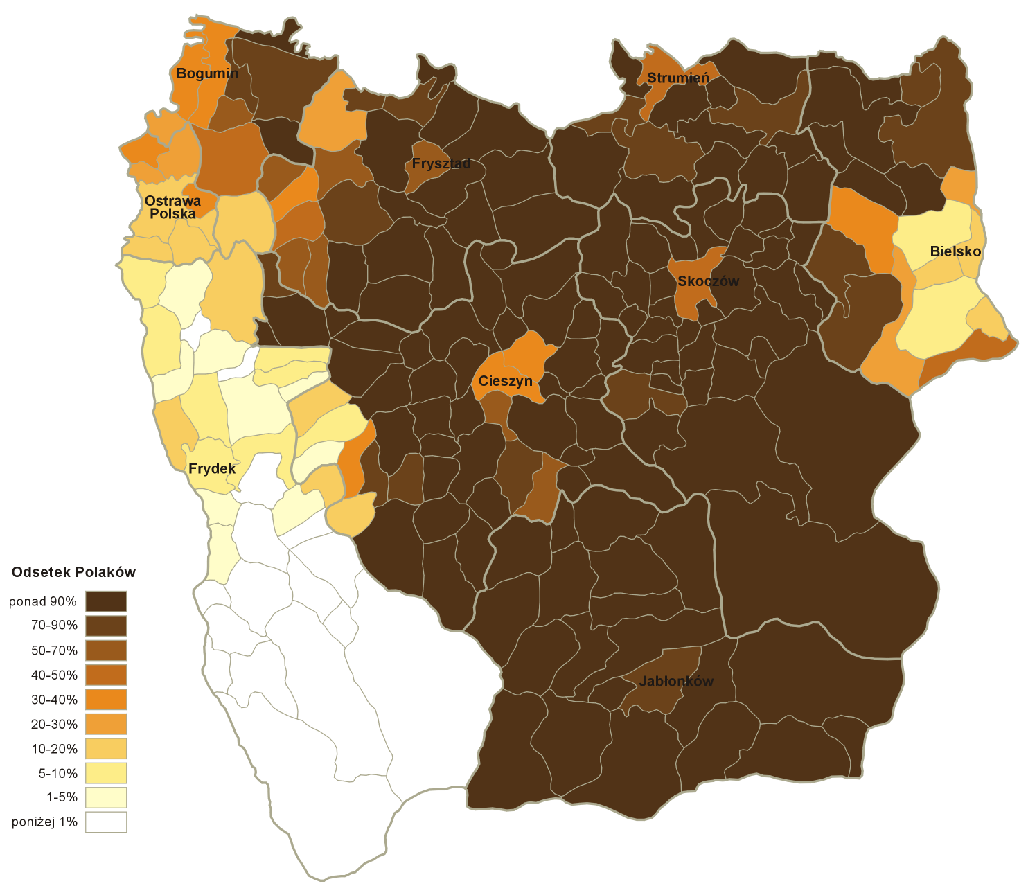
Polski: Odsetek mieszkańców zameldowanych na stałe w gminach Księstwa Cieszyńskiego w 1910 roku posługujących się polskim językiem potocznym. Dane ludnościowe oraz granice gmin i powiatów na podstawie mapy: F. Popiołek, T. Golachowski Rozsiedlenie ludności polskiej w Księstwie Cieszyńskim 1910, Rada Narodowa Księstwa Cieszyńskiego; opisano ówczesne miasta powiatowe
English: Polish-speaking population in the Duchy of Teschen in 1910. Population and communes & counties boundaries according to the map F. Popiołek, T. Golachowski Rozsiedlenie ludności polskiej w Księstwie Cieszyńskim 1910, Rada Narodowa Księstwa Cieszyńskiego |
| Date | |
| Source | Own work, based on the map: F. Popiołek, T. Golachowski Rozsiedlenie ludności polskiej w Księstwie Cieszyńskim, Rada Narodowa Księstwa Cieszyńskiego, 1910] |
| Author | Aotearoa |
| Other versions |
|


Licensing
I, the copyright holder of this work, hereby publish it under the following licenses:

|
Permission is granted to copy, distribute and/or modify this document under the terms of the GNU Free Documentation License, Version 1.2 or any later version published by the Free Software Foundation; with no Invariant Sections, no Front-Cover Texts, and no Back-Cover Texts. A copy of the license is included in the section entitled GNU Free Documentation License. |
This file is licensed under the Creative Commons Attribution-Share Alike 3.0 Unported, 2.5 Generic, 2.0 Generic and 1.0 Generic license.
- You are free:
- to share – to copy, distribute and transmit the work
- to remix – to adapt the work
- Under the following conditions:
- attribution – You must give appropriate credit, provide a link to the license, and indicate if changes were made. You may do so in any reasonable manner, but not in any way that suggests the licensor endorses you or your use.
- share alike – If you remix, transform, or build upon the material, you must distribute your contributions under the same or compatible license as the original.
You may select the license of your choice.
File history
Click on a date/time to view the file as it appeared at that time.
| Date/Time | Thumbnail | Dimensions | User | Comment | |
|---|---|---|---|---|---|
| current | 14:41, 31 October 2012 | | 1,484 × 1,292 (394 KB) | Aotearoa | Poprawa dwóch błędów na mapie |
| 18:16, 30 October 2012 |  | 1,484 × 1,292 (393 KB) | Aotearoa | {{Information |Description={{pl|Odsetek Polaków w gminach Księstwa Cieszyńskiego w 1910 roku. Dane ludnościowe oraz granice gmin i powiatów na podstawie mapy: [http://laziska_gorne.fotopolska.eu/22256,foto.html F. Popiołek, T. Golachowski ''Rozsi... |
File usage
The following pages on the English Wikipedia use this file (pages on other projects are not listed):
Global file usage
The following other wikis use this file:
- Usage on de.wikipedia.org
- Usage on eo.wikipedia.org
- Usage on es.wikipedia.org
- Usage on pl.wikipedia.org