
Erma, New Jersey
Erma, New Jersey | |
|---|---|
 Erma Volunteer Fire Company | |
 Map of Erma CDP in Cape May County. Inset: Location of Cape May County in New Jersey. | |
| Coordinates: 38°59′49″N 74°53′28″W / 38.996931°N 74.891122°W | |
| Country | |
| State | |
| County | Cape May |
| Township | Lower |
| Area | |
| • Total | 3.01 sq mi (7.80 km2) |
| • Land | 2.92 sq mi (7.55 km2) |
| • Water | 0.10 sq mi (0.25 km2) 2.97% |
| Elevation | 10 ft (3 m) |
| Population | |
| • Total | 2,031 |
| • Density | 696.26/sq mi (268.84/km2) |
| Time zone | UTC−05:00 (Eastern (EST)) |
| • Summer (DST) | UTC−04:00 (Eastern (EDT)) |
| ZIP Code | |
| Area code | 609 |
| FIPS code | 34-21660[5][6][7] |
| GNIS feature ID | 02389049[5][8] |


Erma is an unincorporated community and census-designated place (CDP)[9] located within Lower Township in Cape May County, in the U.S. state of New Jersey.[10] As of the 2020 United States census, the CDP's population was 2,031,[3] a decline of 103 from the 2010 census count of 2,134.[11]
Geography[edit]
According to the United States Census Bureau, the CDP had a total area of 3.360 square miles (8.702 km2), including 3.260 square miles (8.443 km2) of land and 0.100 square miles (0.258 km2) of water (2.97%).[5][12]
Demographics[edit]
| Census | Pop. | Note | %± |
|---|---|---|---|
| 1990 | 2,045 | — | |
| 2000 | 2,088 | 2.1% | |
| 2010 | 2,134 | 2.2% | |
| 2020 | 2,031 | −4.8% | |
| Population sources: 2000[13] 2010[11] 2020[3] | |||
2010 census[edit]
The 2010 United States census counted 2,134 people, 821 households, and 596 families in the CDP. The population density was 654.6 per square mile (252.7/km2). There were 920 housing units at an average density of 282.2 per square mile (109.0/km2). The racial makeup was 95.74% (2,043) White, 1.12% (24) Black or African American, 0.23% (5) Native American, 0.94% (20) Asian, 0.14% (3) Pacific Islander, 0.70% (15) from other races, and 1.12% (24) from two or more races. Hispanic or Latino of any race were 2.62% (56) of the population.[11]
Of the 821 households, 26.6% had children under the age of 18; 55.9% were married couples living together; 10.8% had a female householder with no husband present and 27.4% were non-families. Of all households, 22.9% were made up of individuals and 9.9% had someone living alone who was 65 years of age or older. The average household size was 2.59 and the average family size was 3.04.[11]
21.2% of the population were under the age of 18, 8.4% from 18 to 24, 21.4% from 25 to 44, 34.3% from 45 to 64, and 14.8% who were 65 years of age or older. The median age was 44.4 years. For every 100 females, the population had 96.7 males. For every 100 females ages 18 and older there were 94.3 males.[11]
2000 census[edit]
As of the 2000 United States census[6] of 2000, there were 2,088 people, 751 households, and 561 families living in the CDP. The population density was 240.7/km2 (623.3/mi2). There were 846 housing units at an average density of 97.5/km2 (252.6/mi2). The racial makeup of the CDP was 97.22% White, 0.48% African American, 0.05% Native American, 1.05% Asian, 0.48% from other races, and 0.72% from two or more races. Hispanic or Latino of any race were 1.68% of the population.[13]
There were 751 households, out of which 38.9% had children under the age of 18 living with them, 60.7% were married couples living together, 10.3% had a female householder with no husband present, and 25.2% were non-families. 20.8% of all households were made up of individuals, and 8.7% had someone living alone who was 65 years of age or older. The average household size was 2.77 and the average family size was 3.24.[13]
In the CDP the population was spread out, with 28.4% under the age of 18, 7.3% from 18 to 24, 27.9% from 25 to 44, 24.1% from 45 to 64, and 12.3% who were 65 years of age or older. The median age was 38 years. For every 100 females, there were 97.5 males. For every 100 females age 18 and over, there were 89.6 males.[13]
The median income for a household in the CDP was $64,261, and the median income for a family was $69,063. Males had a median income of $45,694 versus $21,923 for females. The per capita income for the CDP was $20,765. About 1.8% of families and 3.9% of the population were below the poverty line, including 4.9% of those under age 18 and 6.5% of those age 65 or over.[13]
Transportation[edit]
The main transportation route for Erma is U.S. Route 9.
The Cape May Airport is located in Lower Township,[14] and has an Erma postal address though it is not in the CDP.[15][16]
Government and infrastructure[edit]
The Lower Township Police Department station has an Erma address but is outside of the CDP.[17]
Education[edit]

As with other parts of Lower Township, it is served by Lower Township School District for primary grades and Lower Cape May Regional School District (LCMR) for secondary grades; the latter operates Teitelman Middle School and Lower Cape May Regional High School.
The LCMR district describes its facilities as being in Erma;[18] the schools and district headquarters are not in the census-designated place.[15] The Cape May County Herald,[19][20] and the Press of Atlantic City describe the school complex as being in Erma.[21]
The elementary schools are in as follows: David C. Douglass Memorial Elementary School (pre-Kindergarten and Kindergarten) is in Villas CDP. The other three elementary schools are in Cold Spring: Carl T. Mitnick (grades 1-2), Maud Abrams (grades 3-4), and Sandman Consolidated (grades 5-6).
Students are also eligible to attend Cape May County Technical High School in the Cape May Court House area, which serves students from the entire county in its comprehensive and vocational programs, which are offered without charge to students who are county residents.[22][23] Special needs students may be referred to Cape May County Special Services School District in the Cape May Court House area.
Notable people[edit]
People who were born in, residents of, or otherwise closely associated with Erma include:
- Charles W. Sandman Jr. (1921-1985), represented New Jersey's 2nd congressional district from 1967 to 1975.[24]
- Matt Szczur (born 1989), professional baseball player.[25]
References[edit]
- ^ "ArcGIS REST Services Directory". United States Census Bureau. Retrieved October 11, 2022.
- ^ U.S. Geological Survey Geographic Names Information System: Erma Census Designated Place, Geographic Names Information System. Accessed October 18, 2012.
- ^ a b c Census Data Explorer: Erma CDP, New Jersey, United States Census Bureau. Accessed June 15, 2023.
- ^ Look Up a ZIP Code for Erma, NJ, United States Postal Service. Accessed October 18, 2012.
- ^ a b c Gazetteer of New Jersey Places, United States Census Bureau. Accessed July 21, 2016.
- ^ a b U.S. Census website, United States Census Bureau. Accessed September 4, 2014.
- ^ Geographic Codes Lookup for New Jersey, Missouri Census Data Center. Accessed June 9, 2023.
- ^ US Board on Geographic Names, United States Geological Survey. Accessed September 4, 2014.
- ^ State of New Jersey Census Designated Places - BVP20 - Data as of January 1, 2020, United States Census Bureau. Accessed December 1, 2022.
- ^ New Jersey: 2010 - Population and Housing Unit Counts - 2010 Census of Population and Housing (CPH-2-32), United States Census Bureau, August 2012. Accessed October 18, 2012.
- ^ a b c d e DP-1 - Profile of General Population and Housing Characteristics: 2010 Demographic Profile Data for Erma CDP, New Jersey Archived 2020-02-12 at archive.today, United States Census Bureau. Accessed October 18, 2012.
- ^ US Gazetteer files: 2010, 2000, and 1990, United States Census Bureau. Accessed September 4, 2014.
- ^ a b c d e DP-1 - Profile of General Demographic Characteristics: 2000 from the Census 2000 Summary File 1 (SF 1) 100-Percent Data for Erma CDP, New Jersey Archived 2020-02-12 at archive.today, United States Census Bureau. Accessed October 18, 2012.
- ^ "Zoning Map" (PDF). Lower Township. Retrieved September 23, 2020. - The zoning map shows the airport in the township boundaries.
- ^ a b "2010 CENSUS - CENSUS BLOCK MAP: Erma CDP, NJ" (PDF). U.S. Census Bureau. Retrieved September 23, 2020. - The airport is not in the CDP as per the physical location.
- ^ Linehan, Mary. "Air station looks to solve identity crisis" Archived 2013-10-29 at the Wayback Machine, The Cape May Gazette, April 30, 2013. Accessed May 4, 2013. "According to the DRBA maintained website for the Cape May Airport, 'this well-maintained 1,000-acre general aviation airport' is located in Rio Grande, New Jersey, approximately five miles from Cape May. The site does list the airport’s address as being in Erma. Rio Grande is part of Middle Township and Erma is in Lower Township."
- ^ "Directions to the Lower Township Police Department". Lower Township Police Department. Retrieved May 20, 2021.
Our Physical Address: 1389 Langley Road, Erma, NJ 08204
- ^ "Board of Education". Lower Cape May Regional School District. Retrieved September 28, 2020.
[...]in the Administration Building, located at 687 Route 9, Erma, Township of Lower, County of Cape May, State of New Jersey.
- All LCMR School District facilities have the same postal address. - ^ "LCMR Field House to Serve as County's 2nd Covid Vaccination Site". Cape May County Herald. January 28, 2021. Retrieved May 16, 2021.
Lower Cape May Regional High School, in Erma.
(photo caption) - As it is a press release the article itself was written by the government of Lower Township, but the photo caption indicates a different authorship. - ^ "Vaccine Site to Relocate to LCMR". Cape May County Herald. April 25, 2021. Retrieved May 16, 2021.
Lower Cape May Regional High School, in Erma.
(photo caption) - As it is a press release the article was written by the Cape May County Department of Health, but the photo caption indicates a different authorship. - ^ D'Amico, Diane (October 17, 2015). "Stopping bullying in schools not so simple". Press of Atlantic City. Retrieved May 16, 2021.
Lower Cape May Regional High School in Erma
(photo caption) - ^ Frequently Asked Questions, Cape May County Technical High School. Accessed October 27, 2019. "All residents of Cape May County are eligible to attend Cape May County Technical High School.... The Cape May County Technical High School is a public school so there is no cost to residents of Cape May County."
- ^ Technical High School Admissions, Cape May County Technical High School. Accessed October 27, 2019. "All students who are residents of Cape May County may apply to the Technical High School."
- ^ Kerr, Peter. "Ex-Rep. Charles Sandman, Nixon Supporter, Dies", The New York Times, August 27, 1985. Accessed October 18, 2012. "He was 64 and lived in Erma Park, N.J"
- ^ Caldwell, Dave. "Two Sports, One Big Choice", The New York Times, December 16, 2010. Accessed October 20, 2016. "Szczur, a senior from Erma, N.J., gained attention late in the 2009 season after the National Marrow Donor Program determined that his bone marrow was a match for a 13-month-old girl with juvenile leukemia."
Further reading[edit]
Maps:
- Map from the 2010 U.S. Census
- Map from the 2000 U.S. Census.
- Map of Cape May County from the 1990 U.S. Census. Whitesboro-Burleigh is on pages 25, 26, 29, and 30
External links[edit]
- The Cape May Gazette Newspaper serving Erma.
- Erma Tabernacle: A United Methodist Church serving Lower Township NJ.
Municipalities and communities of Cape May County, New Jersey, United States | ||
|---|---|---|
| Cities | 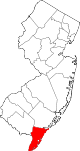 | |
| Boroughs | ||
| Townships | ||
| CDPs | ||
| Other communities | ||