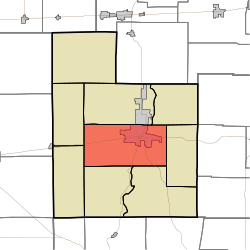
Connersville Township, Fayette County, Indiana
Connersville Township | |
|---|---|
 Location of Connersville Township in Fayette County | |
| Coordinates: 39°37′50″N 85°10′11″W / 39.63056°N 85.16972°W | |
| Country | United States |
| State | Indiana |
| County | Fayette |
| Government | |
| • Type | Indiana township |
| Area | |
| • Total | 32.77 sq mi (84.9 km2) |
| • Land | 32.71 sq mi (84.7 km2) |
| • Water | 0.06 sq mi (0.2 km2) |
| Elevation | 869 ft (265 m) |
| Population | |
| • Total | 11,955 |
| • Density | 375.5/sq mi (145.0/km2) |
| ZIP code | 47331[3] |
| Area code | 765 |
| FIPS code | 18-14950[4] |
| GNIS feature ID | 453246 |
Connersville Township is one of nine townships in Fayette County, Indiana. As of the 2010 census, its population was 12,282 and it contained 5,573 housing units.[5]
History[edit]
Connersville Township was organized in 1819 as one of five original townships of Fayette County containing the namesake town, which was designated the county seat.[6]
John Conner is credited with being the first settler in Connersville Township.[7] He established a trading post which was the center of early pioneer life.[8]
Geography[edit]
According to the 2010 census, the township has a total area of 32.77 square miles (84.9 km2), of which 32.71 square miles (84.7 km2) (or 99.82%) is land and 0.06 square miles (0.16 km2) (or 0.18%) is water.[5]
Cities and towns[edit]
- Connersville (southwest half)
Unincorporated towns[edit]
(This list is based on USGS data and may include former settlements.)
Adjacent townships[edit]
- Harrison Township (north)
- Waterloo Township (northeast)
- Jennings Township (east)
- Jackson Township (southeast)
- Columbia Township (southwest)
- Orange Township (southwest)
- Fairview Township (northwest)
Major highways[edit]
Cemeteries[edit]
The township contains one cemetery, Tullis Chapel.
References[edit]
- "Connersville Township, Fayette County, Indiana". Geographic Names Information System. United States Geological Survey, United States Department of the Interior. Retrieved September 24, 2009.
- United States Census Bureau cartographic boundary files
- ^ "US Board on Geographic Names". United States Geological Survey. October 25, 2007. Retrieved January 31, 2008.
- ^ "Census Bureau profile: Connersville Township, Fayette County, Indiana". United States Census Bureau. May 2023. Retrieved March 24, 2024.
- ^ "Connersville Township IN ZIP Code". zipdatamaps.com. 2023. Retrieved June 16, 2023.
- ^ "U.S. Census website". United States Census Bureau. Retrieved January 31, 2008.
- ^ a b "Population, Housing Units, Area, and Density: 2010 - County -- County Subdivision and Place -- 2010 Census Summary File 1". United States Census. Archived from the original on February 12, 2020. Retrieved May 10, 2013.
- ^ History of Fayette County, Indiana: Containing a History of the Townships, Towns, Villages, Schools, Churches, Industries, Etc. Warner, Beers and Company. 1885. pp. 164.
- ^ History of Fayette County, Indiana: Containing a History of the Townships, Towns, Villages, Schools, Churches, Industries, Etc. Warner, Beers and Company. 1885. pp. 165.
- ^ Barrows, Frederic Irving (1917). History of Fayette County, Indiana: Her People, Industries and Institutions. Bowen, B. F. p. 224.
External links[edit]

