
Coalmont, Colorado
Coalmont, Colorado | |
|---|---|
 Coalmont  Coalmont | |
| Coordinates: 40°33′45″N 106°26′40″W / 40.5625°N 106.4444°W | |
| Country | |
| State | |
| County | Jackson County[1] |
| Elevation | 8,216 ft (2,504 m) |
| Time zone | UTC-7 (MST) |
| • Summer (DST) | UTC-6 (MDT) |
| ZIP Code[2] | 80480 |
Coalmont is an unincorporated community and U.S. Post Office in Jackson County, Colorado, United States. The town is named for the open-pit lignite coal mines in the area, from which coal was shipped out on the Union Pacific Railroad to the mainline at Laramie, Wyoming.
.jpg)
Geography[edit]
Coalmont is located at 40°33′45″N 106°26′40″W / 40.5625°N 106.4444°W at an elevation of 8,216 feet (2,504 m).
Climate[edit]
Spicer is a weather station roughly 6 miles (9.7 km) south of Coalmont, at an elevation of 8,385 ft (2,556 m). Spicer has a subalpine climate (Köppen Dfc), bordering on a humid continental climate (Köppen Dfb).
| Climate data for Spicer, Colorado, 1991–2020 normals, 1912-2020 extremes: 8385ft (2556m) | |||||||||||||
|---|---|---|---|---|---|---|---|---|---|---|---|---|---|
| Month | Jan | Feb | Mar | Apr | May | Jun | Jul | Aug | Sep | Oct | Nov | Dec | Year |
| Record high °F (°C) | 56 (13) |
65 (18) |
80 (27) |
73 (23) |
82 (28) |
90 (32) |
91 (33) |
91 (33) |
90 (32) |
78 (26) |
70 (21) |
75 (24) |
91 (33) |
| Mean maximum °F (°C) | 43.6 (6.4) |
45.3 (7.4) |
53.0 (11.7) |
63.6 (17.6) |
72.5 (22.5) |
80.2 (26.8) |
84.0 (28.9) |
82.2 (27.9) |
78.2 (25.7) |
68.6 (20.3) |
54.5 (12.5) |
44.0 (6.7) |
83.2 (28.4) |
| Mean daily maximum °F (°C) | 28.5 (−1.9) |
31.1 (−0.5) |
39.5 (4.2) |
49.2 (9.6) |
59.4 (15.2) |
71.0 (21.7) |
76.6 (24.8) |
75.6 (24.2) |
68.3 (20.2) |
55.3 (12.9) |
38.7 (3.7) |
29.1 (−1.6) |
51.9 (11.0) |
| Daily mean °F (°C) | 17.9 (−7.8) |
20.2 (−6.6) |
27.5 (−2.5) |
36.1 (2.3) |
44.8 (7.1) |
53.3 (11.8) |
59.3 (15.2) |
58.1 (14.5) |
51.2 (10.7) |
39.9 (4.4) |
27.2 (−2.7) |
18.9 (−7.3) |
37.9 (3.3) |
| Mean daily minimum °F (°C) | 7.3 (−13.7) |
9.3 (−12.6) |
15.4 (−9.2) |
22.9 (−5.1) |
30.1 (−1.1) |
35.6 (2.0) |
42.0 (5.6) |
40.5 (4.7) |
34.1 (1.2) |
24.6 (−4.1) |
15.8 (−9.0) |
8.8 (−12.9) |
23.9 (−4.5) |
| Mean minimum °F (°C) | −17.5 (−27.5) |
−18.7 (−28.2) |
−9.0 (−22.8) |
2.7 (−16.3) |
15.5 (−9.2) |
24.4 (−4.2) |
31.1 (−0.5) |
30.1 (−1.1) |
16.4 (−8.7) |
4.9 (−15.1) |
−9.1 (−22.8) |
−18.2 (−27.9) |
−25.3 (−31.8) |
| Record low °F (°C) | −48 (−44) |
−50 (−46) |
−36 (−38) |
−17 (−27) |
0 (−18) |
11 (−12) |
19 (−7) |
20 (−7) |
0 (−18) |
−14 (−26) |
−32 (−36) |
−43 (−42) |
−50 (−46) |
| Average precipitation inches (mm) | 0.97 (25) |
1.08 (27) |
1.23 (31) |
1.62 (41) |
1.53 (39) |
1.02 (26) |
1.54 (39) |
1.26 (32) |
1.71 (43) |
1.16 (29) |
1.06 (27) |
0.97 (25) |
15.15 (384) |
| Average snowfall inches (cm) | 17.5 (44) |
20.5 (52) |
19.6 (50) |
15.7 (40) |
5.9 (15) |
0.3 (0.76) |
0.0 (0.0) |
0.0 (0.0) |
1.0 (2.5) |
7.2 (18) |
18.4 (47) |
19.5 (50) |
125.6 (319.26) |
| Average precipitation days (≥ 0.01 in) | 9.0 | 8.3 | 7.6 | 9.5 | 9.4 | 7.7 | 8.8 | 11.0 | 8.7 | 6.4 | 8.7 | 7.3 | 102.4 |
| Average snowy days (≥ 0.1 in) | 8.3 | 7.4 | 7.3 | 6.4 | 1.9 | 0.3 | 0.0 | 0.0 | 0.5 | 2.8 | 8.3 | 8.0 | 51.2 |
| Source 1: NOAA (1981-2010 snowfall & snow days)[3][4] | |||||||||||||
| Source 2: XMACIS2 (records & 1981-2010 monthly max/mins)[5] | |||||||||||||
Geology[edit]
Coalmont, Colorado, is the type locality of the Coalmont Formation.[6]
Mining history[edit]
Coalmont was a mining town associated with the production of coal from the Coalmont Coal District. In the Coalmont Coal District, commercial coal mining from the Coalmont Formation started in 1909 and continued until the close of World War II when coal production ceased. Since then, the mines were inactive, until 1959 when a new open pit mine was opened and some coal was mined and sold in the Denver, Colorado area. However, coal mining ceased a year or two later and there has been no production of coal since that time, despite some coal prospecting in 1964 and 1965. The estimated coal production in 1941 was 1,438,355 tons, and the original reserves at 177,450,000 tons of subbituminous coal.[6][7]
See also[edit]
- Bibliography of Colorado
- Geography of Colorado
- History of Colorado
- Index of Colorado-related articles
- List of Colorado-related lists
- Outline of Colorado
References[edit]
- ^ a b "US Board on Geographic Names". United States Geological Survey. October 25, 2007. Retrieved January 31, 2008.
- ^ "United States Zip Codes". Retrieved December 21, 2021.
- ^ "Spicer, Colorado 1991-2020 Monthly Normals". Retrieved December 8, 2023.
- ^ "Spicer, Colorado 1981-2010 Monthly Normals". Retrieved December 8, 2023.
- ^ "xmACIS". National Oceanic and Atmospheric Administration. Retrieved December 8, 2023.
- ^ a b Hail, W. J., Jr., I968. Geology of southwestern North Park and vicinity, Colorado. U.S. Geologival Survey Bulletin, no. 1257, 119 pp.
- ^ Erdmann, C. E., 1941. Preliminary report on the geology of the Coalmont district, Jackson County, Colorado. US Geological Survey open-file report no. 44-2, 207 pp.,
External links[edit]
 Media from Commons
 News from Wikinews
 Quotations from Wikiquote
 Travel information from Wikivoyage
Municipalities and communities of Jackson County, Colorado, United States | ||
|---|---|---|
| Town | 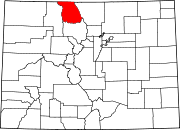 | |
| Unincorporated communities | ||