
Cles
Cles | |
|---|---|
| Comune di Cles | |
 Cles | |
Location of Cles  | |
 Cles Location of Cles in Italy  Cles Cles (Trentino-Alto Adige/Südtirol) | |
| Coordinates: 46°22′N 11°02′E / 46.367°N 11.033°E | |
| Country | Italy |
| Region | Trentino-Alto Adige/Südtirol |
| Province | Trentino (TN) |
| Frazioni | Caltron, Dres, Pez, Maiano, Mechel, Spinazzeda[1] |
| Government | |
| • Mayor | Ruggero Mucchi (since May 11, 2015) (PATT) |
| Area | |
| • Total | 39.17 km2 (15.12 sq mi) |
| Elevation | 658 m (2,159 ft) |
| Population (1 January 2018)[3] | |
| • Total | 7,009 |
| • Density | 180/km2 (460/sq mi) |
| Demonym | Clesiani |
| Time zone | UTC+1 (CET) |
| • Summer (DST) | UTC+2 (CEST) |
| Postal code | 38023 |
| Dialing code | 0463 |
| Patron saint | Santa Maria Assunta |
| Saint day | August 15 |
| Website | Official website |
Cles (German: Glöß; Nones: Clés or Cliès) is a town and comune in Trentino, in the Trentino-Alto Adige/Südtirol region of northern Italy. It is the main town of Val di Non.
It is the main town of and is located in Val di Non. Monte di Cles and Monte Peller (2,319 m (7,608.27 ft) above sea level) are located to the west of the residential area, while Lake Santa Giustina is on the east.
History[edit]
Prior to World War I, Cles was part of the Austrian Empire. After the war, the region was ceded to Italy with the dissolution of the Austro–Hungarian Monarchy.
Lake Santa Giustina[edit]
Lake Santa Giustina is an artificial lake which was created by the dike on the creek Noce. The dam was completed in 1950, is 152 metres high and it was the highest dam in Europe at the time. The lake can contain up to about 180 million cubic metres water, which feeds the turbines of the hydroelectric plant in Taio.[4][5] The lake is named after the location where the dam is placed, which in turn is named after an ancient hermitage of which only ruins are left, covered by a natural hollow of the rock.
Tabula clesiana[edit]
The Tabula clesiana is a bronze plate measuring 49.9 by 37.8 by 0.61 centimetres (19.65 by 14.88 by 0.24 in) that was discovered in 1869 at Campi Neri in Cles. It contains the edict of the Emperor Claudius of 46 AD, which granted Roman citizenship to the Alpine peoples of the Anauni, Sinduni and Tulliasses. It is kept at the Castello del Buonconsiglio Museum in Trento.
The Tabula is an important evidence of the rapid assimilation by the Roman world of the Alpine peoples of farmers-hunters; but also from the point of view of the Roman law the first evidence of the introduction of delatores in the fiscal controversy.[6][7]
Notable people[edit]
- Pietro Antonio Lorenzoni, (1721 – 1782) painter
- Bernardo Clesio, (1484 – 1539) cardinal and diplomat
- Vladimir Barbu, competitive diver (b. 1998)
- Letizia Paternoster, road and track cyclist (b. 1999)
- Andrea Pinamonti, footballer (b. 1999)
- Luca de Aliprandini, alpine skier (b. 1990)
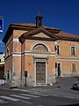
Gallery[edit]
-
 Santa Maria Assunta Parish church
 -
 Saint Roch Church
 -


.jpg)

References[edit]
- ^ Comune di Cles - Statuto.
- ^ "Superficie di Comuni Province e Regioni italiane al 9 ottobre 2011". Italian National Institute of Statistics. Retrieved 16 March 2019.
- ^ "Istat Data". Archived from the original on 2019-12-29. Retrieved 2019-02-24.
- ^ Bartaletti, Fabrizio (2004). Geografia e cultura delle Alpi - Volume 73 di Geografia e società. Milano: Franco Angeli. p. 168. ISBN 88-464-5119-8.
Limited preview (Google Books): Bartaletti, Fabrizio (2004). Geografia e cultura delle Alpi. ISBN 9788846451194. Retrieved April 5, 2011. - ^ Del Tedesco, Elvis, ed. (2010). "Santa Giustina - ProgettoDighe". Retrieved October 23, 2017.
- ^ Spagnuolo Vigorita, 1984: delatorial trial. legal controversy on the patrimonium principis and the status personae.
- ^ A translation of the Tabula
External links[edit]
- Official website (in Italian)

| International | |
|---|---|
| National | |
| Geographic | |
This Trentino-Alto Adige/Südtirol location article is a stub. You can help Wikipedia by expanding it. |