
Chestertown, New York
Chestertown | |
|---|---|
 | |
 Chestertown Location within the state of New York | |
| Coordinates: 43°39′09″N 073°48′03″W / 43.65250°N 73.80083°W[1] | |
| Country | United States |
| State | New York |
| County | Warren County |
| Town | Town of Chester |
| Area | |
| • Total | 3.86 sq mi (9.99 km2) |
| • Land | 3.84 sq mi (9.95 km2) |
| • Water | 0.01 sq mi (0.03 km2) |
| Elevation | 843 ft (257 m) |
| Population (2020) | |
| • Total | 586 |
| • Density | 152.49/sq mi (58.88/km2) |
| Time zone | UTC-5 (Eastern (EST)) |
| • Summer (DST) | UTC-4 (EDT) |
| ZIP code[3] | 12817 |
| Area code | 518 |
| FIPS code[4][5] | 36-15363 |
| GNIS feature ID[5] | 946543 |
| Website | www |
Chestertown is a hamlet of the Town of Chester, in Warren County, New York, United States. It is located by the junction of Route 8 and U.S. Route 9, in the Adirondack Mountains. The population was 677 at the 2010 census, which lists the community as a census-designated place.[6]
History[edit]
The community was founded in 1799 by New Englanders who built mills along its creeks. The first settlement was established around 1790 and was called Chester Four Corners.
The Chestertown Historic District was added to the National Register of Historic Places in 1977.[7]
Geography[edit]
Chestertown is located at 43°39′09″N 073°48′03″W / 43.65250°N 73.80083°W (43.6525664, -73.8009597) and its elevation is 896 feet (273 m).[1] The ZIP code is 12817[3] and it is in the Eastern Time Zone. The nearest city is Glens Falls.
According to the 2010 United States Census, Chestertown has a total area of 3.856 square miles (9.99 km2), of which 3.843 square miles (9.95 km2) is land and 0.013 square miles (0.03 km2) is water.[4]
Demographics[edit]
| Census | Pop. | Note | %± |
|---|---|---|---|
| 2020 | 586 | — | |
| U.S. Decennial Census[8] | |||
Education[edit]
Children from Chestertown, along with children from the neighboring communities of Adirondack, Brant Lake and Pottersville, attend North Warren Central School.
Community and economy[edit]
The old school in the center of the village was transformed into the community center, with public library, town hall and Sheriff's office. There are also a theater and a medical center in the town. Main Street (U.S. Route 9) is lined with many stores. There are several hotels in the area.
The town has one public beach at Loon Lake.
Religion[edit]
There are three churches in the center of Chestertown: the St. John the Baptist Roman Catholic Church of the St. Isaac Jogues Parish Community, the Community United Methodist Church, and the Faith Bible Church. There are also many other churches in the area.
Lakes[edit]
There are three lakes in Chestertown, Friends Lake, Loon Lake, and Forest Lake. Friends and Loon Lakes are surrounded by vacation homes. Forest Lake is privately owned by Forest Lake Camp - a traditional overnight summer camp since 1926.
Gallery[edit]
-
 Junction in the town centre called Chester Four Corners
 -
 Chestertown Post office
 -
 Town of Chester town hall
 -
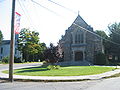 Catholic Church
 -
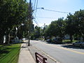 Main Street looking south
 -
 Chester Inn
 -
 Restaurant in Main St
 -
 Church in Main St, south of main junction


References[edit]
- ^ a b c "Chestertown". Geographic Names Information System. United States Geological Survey, United States Department of the Interior. Retrieved January 13, 2013.
- ^ "ArcGIS REST Services Directory". United States Census Bureau. Retrieved September 20, 2022.
- ^ a b "Post Offices By County: Warren County, New York". United States Postal Service. Archived from the original on January 13, 2016. Retrieved January 13, 2013.
- ^ a b "Places: New York". 2010 Census Gazetteer Files. United States Census Bureau. Archived from the original on February 17, 2013. Retrieved January 13, 2013.
- ^ a b "FIPS55 Data: New York". FIPS55 Data. United States Geological Survey. February 23, 2006. Archived from the original on October 19, 2006.
- ^ "Profile of General Population and Housing Characteristics: 2010 Demographic Profile Data: Chestertown CDP, New York". United States Census Bureau. Archived from the original on February 12, 2020. Retrieved January 13, 2013.
- ^ "National Register Information System". National Register of Historic Places. National Park Service. March 13, 2009.
- ^ "Census of Population and Housing". Census.gov. Retrieved June 4, 2016.
External links[edit]
- Town of Chester, NY
- North Warren Chamber of Commerce
- Adirondack Northway Towns
- North Warren Central School
Municipalities and communities of Warren County, New York, United States | ||
|---|---|---|
| City |  | |
| Towns | ||
| Village | ||
| CDPs | ||
| Other hamlets | ||
| Footnotes | ‡This populated place also has portions in an adjacent county or counties | |
| International | |
|---|---|
| National | |