
Cheonggyecheon
| Cheonggyecheon | |
|---|---|
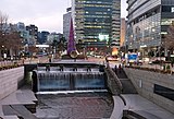
 Cheonggyecheon in 2012 | |
  | |
| Location | |
| Country | South Korea |
| Provinces | Seoul |
| Physical characteristics | |
| Source | Suseongdong Valley in Inwangsan |
| • location | Ogin, Jongno, Seoul |
| Mouth | Jungnangcheon |
• location | Yongdap, Seongdong, Seoul |
| Length | 10.92 km (6.79 mi)[1] |
| Basin size | 50.96 km2 (19.68 sq mi)[1] |
| Basin features | |
| Tributaries | |
| • left | Seongbukcheon, Jeongneungcheon |
| Korean name | |
| Hangul | 청계천 |
| Hanja | |
| Revised Romanization | Cheonggyecheon |
| McCune–Reischauer | Ch'ŏnggyech'ŏn |
Cheonggyecheon (Korean: 청계천, Korean pronunciation: [t͡ɕʰʌ̹ŋ.ɡje̞.t͡ɕʰʌ̹ːn]) is a 10.9-kilometre-long (6.8 mi) stream and public space in downtown Seoul, South Korea. A natural stream sourced from the Suseongdong Valley in Inwangsan, it was historically maintained as part of Seoul's early sewerage until the mid-20th century, when post-Korean War rapid economic development and deteriorating conditions prompted the filling of the stream with concrete and the construction of an elevated freeway, the Cheonggye Expressway, in its place. In 2003, the city government began an urban renewal project to disassemble the expressway and restore the stream, which was completed in 2005 at a cost of over ₩386 billion (approximately US$281 million).
The Cheonggyecheon restoration project initially attracted significant public criticism, but since its opening in 2005 it has become popular among residents and tourists.
Geography[edit]
Cheonggyecheon is an 10.84 km (6.74 mi) stream flowing west to east through downtown Seoul,[2] and then meeting Jungnangcheon, which connects to the Han River and empties into the Yellow Sea.[3]
History[edit]

The stream was named as Gaecheon ("open stream") after the first refurbishment project to construct a drainage system during the Joseon period. The work, which included dredging and bolstering the banks of the stream and building bridges, was carried out every 2–3 years during this period from the reign of Taejong, the third king of Joseon. King Yeongjo especially undertook the refurbishment work as a national project.[4]
Gaecheon was renamed to Cheonggyecheon, its current name, when Korea was under Japanese rule. During this time, financial difficulties disrupted and prevented Japanese forces from covering up the stream despite several attempts to do so.[5][6]
After the Korean War, more people migrated into Seoul to make their living and settled down along the stream in shabby makeshift houses. The accompanying trash, sand, and waste, and deteriorating conditions resulted in an eyesore for the city. The stream was covered up with concrete over 20 years starting in 1958, and a 5.6 km-long (3.5 mi), 16 m-wide (52 ft) elevated highway was completed in 1976. The area became an example of successful industrialization and modernization of South Korea.[5]
Restoration[edit]


In July 2003, Mayor of Seoul Lee Myung-bak, initiated a project to remove the elevated highway and restore the stream. It was a major undertaking since the highway had to be removed and years of neglect and development had left the stream nearly dry. 120,000 tons of water were to be pumped in daily from the Han River, its tributaries, and groundwater from subway stations.[7]
To address the consequent traffic problem, the Cheonggyecheon Restoration Project Headquarters established traffic flow measures in the downtown section affected by the restoration work and coordinated changes in the downtown traffic system based on the research of the Cheonggyecheon Restoration Research Corps.[5]
The restoration of two historic bridges, Gwangtonggyo and Supyogyo, was also a contentious issue, as several interest groups voiced opinions on how to restore historical and cultural sites and remains and whether to replace the bridges or not.[5]
The Cheonggyecheon restoration project had the purpose of preserving the unique identity of the natural environment and the historic resources in the CBD of Seoul, and to reinforce the surrounding business area with information technology, international affairs and digital industries.[5]
Achievements[edit]

The stream was opened to the public in September 2005 and was lauded as a major success in urban renewal and beautification. However, there was considerable opposition from the previous mayoral administration of Goh Kun, which feared gentrification of the adjacent areas that housed many shops and small businesses in the machine trades.[citation needed]
Creating an environment with clean water and natural habitats was the most significant achievement of the project. Species of fish, birds, and insects have increased significantly as a result of the stream excavation.[8] The stream helps to cool down the temperature on the nearby areas by 3.6 °C on average versus other parts of Seoul.[9] The number of vehicles entering downtown Seoul has decreased by 2.3%, with an increasing number of users of buses (by 1.4%) and subways (by 4.3%: a daily average of 430,000 people) as a result of the demolition of the two heavily used roads.[10]
The project sped up traffic around the city when the motorway was removed. It has been cited as a real-life example of Braess's paradox.[11]
Cost[edit]
Budgeted at ₩349 billion, the final cost of the project was over ₩386 billion (approximately US$281 million).[5]
Some Korean environmental organizations have criticized its high costs and lack of ecological and historical authenticity, calling it purely symbolic and not truly beneficial to the city's eco-environment. Instead of using the restoration as an instrument of urban development the environmental organizations have called for a gradual long-term ecological and historical recovery of the entire Cheonggyecheon stream basin and its ecological system.[12]
The cost of managing Cheonggyecheon has been rising every year.[13] From October 2005 to the end of 2016, maintenance and management cost of Cheonggyecheon totalled ₩85.7 billion, which averaged out to ₩7.1 billion per year.[14]
Gallery[edit]
-
 The beginning of the Cheonggye Stream
 -
 Cheonggye Stream flowing through Seoul
 -
 The beginning of the Cheonggye Stream at night
 -
 The view of Cheonggyecheon at night
 -
 Cheonggyecheon around Mojeongyo

.jpg)


.JPG)
See also[edit]
- Rivers of Korea
- Daylighting, the process of revealing rivers which have previously been covered over as part of urban development
- Seoul Peace Market
- Gwangjang Market
- Gwanghwamun Plaza
- Seoul Plaza
Notes[edit]
- ^ a b 2013년 한국하천일람 [List of Rivers of South Korea, 2013] (PDF) (in Korean). Han River Flood Control Office, Republic of Korea. 31 December 2012. pp. 108–109. Archived from the original (PDF) on 4 March 2016. Retrieved 8 July 2014.
- ^ "Cheonggyecheon (Stream) | global_main_en>Facility management". www.sisul.or.kr. Retrieved 2023-08-18.
- ^ Jones, Terril (1987-04-12). "Cleanup Makes It a Source of National Pride : Seoul's Once-Dead Han River Brought Back to Life". Los Angeles Times. Retrieved 2023-08-18.
- ^ PDF, in Korean[permanent dead link]. Retrieved on 2010-11-21.
- ^ a b c d e f Official website of Cheonggyecheon, Retrieved on 2010-11-21.
- ^ "Removing Freeways - Restoring Cities". Preservation Institute. Retrieved 4 July 2018.
- ^ *Park, Kil-dong. (2007). Cheonggyecheon Restoration Project Archived July 17, 2011, at the Wayback Machine.
- ^ Urban waterways: Seoul peels back the pavement and reveals a river - Cheonggyecheon, Livable cities, Seoul | TerraPass: Fight global warming, reduce your carbon footprint Archived August 2, 2009, at the Wayback Machine. TerraPass (2009-07-17). Retrieved on 2010-11-21.
- ^ donga.com[English donga]. English.donga.com (2005-08-12). Retrieved on 2010-11-21.
- ^ "Cheonggye Plaza Season Market -". 18 September 2012.
- ^ Easley, D and Kleinberg, J: "Networks", page 71. Cornell Store Press, 2008
- ^ Cho, Myun-Rae. (2010). "The Politics of Urban Nature Restoration".
- ^ Kang (강), Gyeong-ji (경지) (2011-11-20). 청계천 물길 따라 해마다 80억원 증발. edaily (in Korean). Archived from the original on 2016-03-04. Retrieved 2011-12-03.
- ^ 1년 71억의 세금이 청계천에 들어간다 (in Korean). Media Today. 2017-10-15. Retrieved 2021-01-22.
Further reading[edit]
- Cho, Myung-Rae (2010-01-01). "The politics of urban nature restoration: The case of Cheonggyecheon restoration in Seoul, Korea". International Development Planning Review. 32 (2). Liverpool, UK: Liverpool University Press: 145–165. doi:10.3828/idpr.2010.05. ISSN 1474-6743.
- Shin, J. H. (2004). "Dream and Hope of Korea, Cheonggyecheon Restoration". Magazine of Korean Water Resources Association. 37 (1).
- Križnik, B. (2010). "Urban Regeneration in Global Seoul: New Approaches, Old Divides?". Wiener Beiträge zur Koreaforschung. 2 (1).
- Shin, Hisup (2005). "Uncovering Chonggyechon: The Ruins of Modernization and Everyday Life". Korean Studies. 29 (1): 95–113. doi:10.1353/ks.2006.0009. ISSN 1529-1529.
- Temperton, Vicky M.; Higgs, Eric; Choi, Young D.; Allen, Edith; Lamb, David; Lee, Chang-Seok; Harris, James; Hobbs, Richard J.; Zedler, Joy B. (May 2014). "Flexible and Adaptable Restoration: An Example from South Korea". Restoration Ecology. 22 (3): 271–278. doi:10.1111/rec.12095. S2CID 85994473.
- Richardson, Harry Ward; Bae, Chang-Hee Christine (1 January 2011). "Quality of life and liveable cities". Regional and Urban Policy and Planning on the Korean Peninsula. Edward Elgar Publishing. pp. 69–. ISBN 978-1-84980-579-7.
External links[edit]
- "Cheonggyecheon". Seoul Metropolitan Facilities Management Corporation.
- "Cheonggyecheon". Official Seoul City Tourism Website. Archived from the original on 2012-03-14.
- "A path for the people in the heart of Seoul". www.museeum.com. Museeum. Retrieved 5 June 2021.
- Video on YouTube
37°34′12″N 127°0′23″E / 37.57000°N 127.00639°E
| Authority control databases: National |
|---|