
Cairo, Georgia
Cairo, Georgia | |
|---|---|
 Cairo City Hall | |
 Flag  Seal | |
| Nicknames: "Georgia's Hospitality City", and "The Syrup City" | |
 Location in Grady County and the state of Georgia | |
| Coordinates: 30°52′39″N 84°12′5″W / 30.87750°N 84.20139°W | |
| Country | United States |
| State | Georgia |
| County | Grady |
| Government | |
| • Mayor | Booker Gainor |
| Area | |
| • Total | 9.95 sq mi (25.77 km2) |
| • Land | 9.81 sq mi (25.42 km2) |
| • Water | 0.14 sq mi (0.35 km2) |
| Elevation | 243 ft (74 m) |
| Population (2020) | |
| • Total | 10,179 |
| • Density | 1,037.19/sq mi (400.44/km2) |
| Time zone | UTC-5 (Eastern (EST)) |
| • Summer (DST) | UTC-4 (EDT) |
| ZIP codes | 39827, 39828 |
| Area code | 229 |
| FIPS code | 13-12400[2] |
| GNIS feature ID | 0354934[3] |
| Website | syrupcity |
Cairo (/ˈkeɪroʊ/) is a city in Grady County, Georgia, United States. As of the 2020 census, the city had a population of 10,179. The city is the county seat of Grady County.[4]
History[edit]
Cairo was founded in 1835. It was incorporated as a town in 1870 and as a city in 1906. In 1905, Cairo was designated seat of the newly formed Grady County.[5] The city was named after Cairo, the capital of Egypt.[6]
Geography[edit]
Cairo is located in central Grady County at 30°52′39″N 84°12′5″W / 30.87750°N 84.20139°W (30.8774, -84.2013).[3] U.S. Route 84 (38th Boulevard) passes through the northern part of the city, leading east 14 miles (23 km) to Thomasville and west 24 miles (39 km) to Bainbridge. Valdosta is 59 miles (95 km) to the east, and Dothan, Alabama, is 79 miles (127 km) to the west on US 84. Georgia State Route 93 passes through the center of Cairo as Broad Street and Fifth Street; it leads north 19 miles (31 km) to Pelham and south 12 miles (19 km) to U.S. Route 319, north of the Florida border. Tallahassee, Florida, is 33 miles (53 km) to the south.
According to the United States Census Bureau, Cairo has a total area of 9.8 square miles (25.4 km2), of which 9.7 square miles (25.1 km2) is land and 0.1 square miles (0.3 km2), or 1.38%, is water.[7]
Climate[edit]
The climate in this area is characterized by relatively high temperatures and evenly distributed precipitation throughout the year. According to the Köppen Climate Classification system, Cairo has a humid subtropical climate, abbreviated "Cfa" on climate maps.[8]
| Climate data for Cairo, Georgia | |||||||||||||
|---|---|---|---|---|---|---|---|---|---|---|---|---|---|
| Month | Jan | Feb | Mar | Apr | May | Jun | Jul | Aug | Sep | Oct | Nov | Dec | Year |
| Mean daily maximum °F (°C) | 64 (18) |
66 (19) |
73 (23) |
80 (27) |
86 (30) |
90 (32) |
91 (33) |
91 (33) |
87 (31) |
81 (27) |
71 (22) |
65 (18) |
79 (26) |
| Mean daily minimum °F (°C) | 42 (6) |
42 (6) |
48 (9) |
55 (13) |
62 (17) |
68 (20) |
70 (21) |
70 (21) |
67 (19) |
57 (14) |
46 (8) |
42 (6) |
56 (13) |
| Average precipitation inches (mm) | 3.9 (99) |
4.1 (100) |
5.3 (130) |
3.9 (99) |
3.4 (86) |
5.5 (140) |
6.4 (160) |
5.6 (140) |
4.4 (110) |
2.5 (64) |
2.6 (66) |
3.5 (89) |
51.2 (1,300) |
| Source: Weatherbase [9] | |||||||||||||
Demographics[edit]
| Census | Pop. | Note | %± |
|---|---|---|---|
| 1880 | 275 | — | |
| 1890 | 521 | 89.5% | |
| 1900 | 690 | 32.4% | |
| 1910 | 1,505 | 118.1% | |
| 1920 | 1,908 | 26.8% | |
| 1930 | 3,169 | 66.1% | |
| 1940 | 4,653 | 46.8% | |
| 1950 | 5,577 | 19.9% | |
| 1960 | 7,427 | 33.2% | |
| 1970 | 8,061 | 8.5% | |
| 1980 | 8,777 | 8.9% | |
| 1990 | 9,035 | 2.9% | |
| 2000 | 9,239 | 2.3% | |
| 2010 | 9,607 | 4.0% | |
| 2020 | 10,179 | 6.0% | |
| U.S. Decennial Census[10] | |||
| Race / Ethnicity (NH = Non-Hispanic) | Pop 2010[11] | Pop 2020[12] | % 2010 | % 2020 |
|---|---|---|---|---|
| White alone (NH) | 3,416 | 3,293 | 35.56% | 32.35% |
| Black or African American alone (NH) | 4,601 | 4,688 | 47.89% | 46.06% |
| Native American or Alaska Native alone (NH) | 27 | 27 | 0.28% | 0.27% |
| Asian alone (NH) | 52 | 68 | 0.54% | 0.67% |
| Pacific Islander alone (NH) | 10 | 3 | 0.10% | 0.03% |
| Some Other Race alone (NH) | 19 | 50 | 0.20% | 0.49% |
| Mixed Race or Multi-Racial (NH) | 98 | 213 | 1.02% | 2.09% |
| Hispanic or Latino (any race) | 1,384 | 1,837 | 14.41% | 18.05% |
| Total | 9,607 | 10,179 | 100.00% | 100.00% |
As of the 2020 United States census, there were 10,179 people, 3,567 households, and 2,169 families residing in the city.
Education[edit]
Grady County Schools serves the city. Cairo High School, located in Cairo serves as a central high school for all of Grady County. Elementary schools serving students in the city include Eastside Elementary, Northside Elementary and Southside Elementary. Washington Middle School serves Cairo residents.[13]
A campus of the Southern Regional Technical College is located in Cairo.
Health[edit]
Grady General Hospital serves the city. A 60-bed acute care facility, it has been affiliated with John D. Archbold Memorial Hospital in Thomasville since 1985.[14]
Notable people[edit]
- Notable Cairo people include:
-
 Jackie Robinson,
born 1919,
American professional baseball second baseman who became the first African American to play in Major League Baseball (MLB) in the modern era. -

-
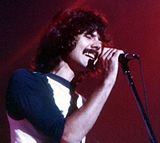 Mickey Thomas,
born 1949,
American rock singer, best known as one of the lead vocalists of Jefferson Starship and Starship. -


- Teresa Edwards, former professional basketball player and an Olympic gold medalist
- Emerson Hancock, former pitcher for University of Georgia and selected to the Seattle Mariners as the 6th overall pick in the 2020 MLB Draft.
- Willie Harris, outfielder and second baseman in Major League Baseball from 2001 through 2012, member of the 2005 World Champion Chicago White Sox
- Bryan Johnson, former professional motocross racer.
- John Monds, 2010 Libertarian gubernatorial candidate for the state of Georgia
- David Ponder, former defensive tackle for the Dallas Cowboys
- Ernest Riles, shortstop and third baseman in Major League Baseball
- Jackie Robinson, Baseball Hall of Famer; first person to break the color barrier in Major League Baseball; born in Cairo
- Matthew "Mack" Robinson, Olympic silver medalist, older brother of Jackie Robinson
- Daryle Singletary, country music singer
- George Thornewell Smith, Georgia politician
- Bill Stanfill, former All-Pro National Football League defensive end
- Mickey Thomas, lead singer of Jefferson Starship
- Bobby Walden, former punter for the Pittsburgh Steelers and Minnesota Vikings
- Hurston Waldrep, baseball pitcher
- J. J. Wilcox, safety for the New York Jets
- Arthur L. Williams Jr., founder of Primerica Financial Services
- Curley Williams, country music singer and songwriter; born near Cairo in Grady County
References[edit]
- ^ "2020 U.S. Gazetteer Files". United States Census Bureau. Retrieved December 18, 2021.
- ^ "U.S. Census website". United States Census Bureau. Retrieved January 31, 2008.
- ^ a b "Cairo, Georgia". Geographic Names Information System. United States Geological Survey, United States Department of the Interior.
- ^ "Find a County". National Association of Counties. Archived from the original on May 31, 2011. Retrieved June 7, 2011.
- ^ Hellmann, Paul T. (May 13, 2013). Historical Gazetteer of the United States. Routledge. p. 222. ISBN 978-1135948597. Retrieved November 30, 2013.
- ^ Logue, Victoria; Logue, Frank (1997). Touring the Backroads of North and South Georgia. John F. Blair, Publisher. p. 412. ISBN 978-0-89587-171-8.
- ^ "Geographic Identifiers: 2010 Demographic Profile Data (G001): Cairo city, Georgia". American Factfinder. U.S. Census Bureau. Retrieved November 23, 2016.[dead link]
- ^ Climate Summary for Cairo, Georgia
- ^ "Weatherbase.com". Weatherbase. 2013. Retrieved on September 28, 2013.
- ^ "Census of Population and Housing". Census.gov. Retrieved June 4, 2015.
- ^ "P2 Hispanic or Latino, and Not Hispanic or Latino by Race – 2010: DEC Redistricting Data (PL 94-171) – Cairo city, Georgia". United States Census Bureau.
- ^ "P2 Hispanic or Latino, and Not Hispanic or Latino by Race – 2020: DEC Redistricting Data (PL 94-171) – Cairo city, Georgia". United States Census Bureau.
- ^ "Schools." Grady County Schools. Retrieved on April 9, 2009.
- ^ "Grady General Hospital". Archbold Medical Center. Retrieved March 30, 2017.
External links[edit]
Municipalities and communities of Grady County, Georgia, United States | ||
|---|---|---|
| Cities |  | |
| CDP | ||
| Unincorporated communities | ||
| International | |
|---|---|
| National | |
| Geographic | |