
Cabeceiras de Basto
Cabeceiras de Basto | |
|---|---|
 Flag  Coat of arms | |
 | |
| Coordinates: 41°32′N 8°01′W / 41.533°N 8.017°W | |
| Country | |
| Region | Norte |
| Intermunic. comm. | Ave |
| District | Braga |
| Parishes | 12 |
| Government | |
| • President | Francisco Alves (PS) |
| Area | |
| • Total | 241.82 km2 (93.37 sq mi) |
| Population (2011) | |
| • Total | 16,710 |
| • Density | 69/km2 (180/sq mi) |
| Time zone | UTC±00:00 (WET) |
| • Summer (DST) | UTC+01:00 (WEST) |
| Website | cm-cabeceiras-basto.pt |
Cabeceiras de Basto (Portuguese pronunciation: [kɐβɨˈsɐjɾɐʒ ðɨ ˈβaʃtu] ⓘ) is a municipality in the district of Braga in Portugal. The population in 2011 was 16,710,[1] in an area of 241.82 km².[2]
The municipality borders the municipality of Montalegre to the north, Boticas to the northeast, Ribeira de Pena to the east, Mondim de Basto to the southeast, Celorico de Basto to the south, Fafe to the west and Vieira do Minho to the northwest.
The present mayor is Francisco Alves, elected by the Socialist Party. The municipal holiday is September 29.
Parishes[edit]
Administratively, the municipality is divided into 12 civil parishes (freguesias):[3]
- Abadim
- Alvite e Passos
- Arco de Baúlhe e Vila Nune
- Basto
- Bucos
- Cabeceiras de Basto
- Cavez
- Faia
- Gondiães e Vilar de Cunhas
- Pedraça
- Refojos de Basto, Outeiro e Painzela
- Rio Douro
Gallery[edit]
-
 Saint Michael's Monastery
 -
 Basto's Statue
 -
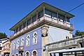 Culture House

.jpg)
.jpg)
References[edit]
- ^ Instituto Nacional de Estatística Archived November 15, 2016, at the Wayback Machine
- ^ "Áreas das freguesias, concelhos, distritos e país". Archived from the original on 2018-11-05. Retrieved 2018-11-05.
- ^ Diário da República. "Law nr. 11-A/2013, page 552 30" (pdf) (in Portuguese). Retrieved 20 July 2014.
| Municipalities | |
|---|---|
| Museums | |
| International | |
|---|---|
| Geographic | |
| Other | |
This Braga District location article is a stub. You can help Wikipedia by expanding it. |