
Gelemo


Gelemo or Gelomo[4][a] (full name: Gelomoring)[4] is a border village in the Upper Subansiri district, Arunachal Pradesh, India. It is on the bank of the Tsari Chu river before its confluence with the Subansiri River, at a distance of "two days march" from the Indian claimed border at Longju.[7] The present Line of Actual Control between China and India is at roughly half that distance.
Location[edit]
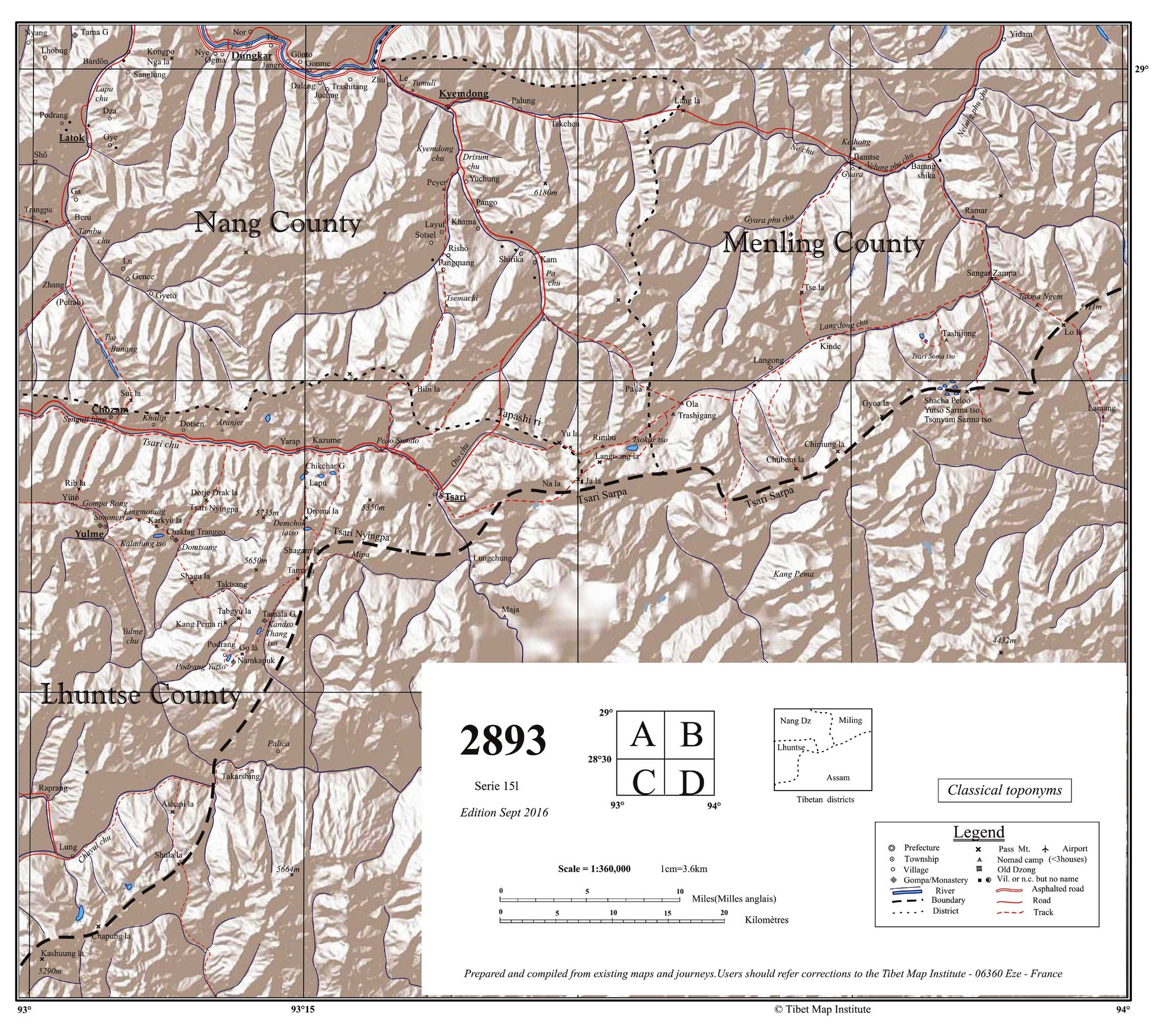
Gelemo is in Limeking Circle of the Upper Subansiri district, one of the border areas adjoining the China–India border. The Tsari Chu river, called Gallen or Gelling by the Tagin people of the region, flows here from Migyitun in Tibet, traditionally considered a Tibetan border town. It joins the Subansiri River at Gelensiniak.
Gelemo is at an elevation of 1,790 metres (5,870 ft), at a distance of 17 kilometres (11 mi) from Gelensiniak. Upstream from Gelemo, 6 kilometres (3.7 mi) to the north, is the village of Bidak (also called Redding Camp).[5][8][b]
History[edit]
An Indian expedition led by political officer S. M. Krishnatry in 1956 was told that Gelomo was the home of the Gibu-Gilo tribe of the Tagin people, but they were almost extinct with only one survivor left, who lived in Limeking. The location was controlled by the Mara tribe at that time, who used it as a hunting ground.[6]
Tsari pilgrimage[edit]
Gelemo lies on the route of the 12-yearly Tsari pilgrimage of the Tibetans around the Dakpa Sheri mountain. The pilgrimage went down the Tsari Chu valley up to Gelensiniak and returned via the Subansiri valley, back into the Tibetan territory.[9]
The last Tsari pilgrimage was conducted in 1956, after which the Sino-Indian border conflict put a stop to the relations between the two regions.[10]
Sino-Indian border conflict[edit]
After the Longju incident in 1959, the Assam Rifles border troops stationed at Longju retreated to a place named "Gallen", which was most likely Gelemo.[11][7] Afterwards, a new border post was established at Maja,[c] 3 miles south of Longju.[15] During the 1962 Sino-Indian War, the Maja post was withdrawn, along with all other posts, since the Chinese attacked with an overwhelming force. The withdrawing forces were said to have been attacked from the rear near Reding (Bidak). The Chinese forces were in occupation of the entire area up to Limeking for the duration of the war.[16]
After the war, China proposed that both the sides should withdraw 20 km from the Line of Actual Control. Even though India did not accept the condition, it appears to have set up a new border post further away, 10 kilometres (6.2 mi) south of Longju.[17][18][19] The local people call this location New Maza and distinguish it from the original Maja village.[13][20][21] The present Line of Actual Control is believed to run between the New Maja Post and the Chinese border post at Xingqiangpu Zhang.
In January 2021, news reports appeared stating that China had built a large 100-home civilian village near the original Maja village.[22][21] The Chinese media have referred to it as "Lowa Xincun" (Chinese: 珞瓦新村; pinyin: Luò wǎ xīncūn).[23][d]
Demographics[edit]
Gelemo has a population of 40 people living in 11 households, as per the 2011 census.[8] Bidak (Redding Camp) has a population of 39 people in 7 households.[8]
Facilities[edit]
Gelemo is being developed as a "model village" by the Government of Arunachal Pradesh.[24] Solar street lights were installed in 2019.[25] A potable water supply was installed in 2020. Irrigation canals, healthcare facilities, and a community hall are scheduled for construction.[24]
In 2017, Indian Army set up Sawaiman[e] Primary School in the Gelemo village.[26][27]
Transportation[edit]
There is a helipad at Gelemo, maintained by the Government of Arunachal Pradesh.[28]
The Border Roads Organisation of India built a road link between Tame Chung Chung (near Gelensiniak) and Bidak in 2018. During its construction, Gelemo served as a construction base with all the construction equipment air lifted there in pieces and assembled locally.[29] The road connectivity is still seen as being poor.[30]
Notes[edit]
- ^ The spelling used by the Indian Army is "Gelemo", whereas the census records use "Gelomo". The name is also spelt Galemo,[5] Gilomo,[6] and Gelong. Older documents possibly misspelt it as Gallen.[7]
- ^ The Survey of India maps still use the name "Redding Camp". It is not to be confused with Redding, an entirely different village in the Taksing Circle.
- ^ Alternative spellings include Majha[12] and Maza.[13] The Tibetan name of the location appears to be Lungchung.[14]
- ^ The name means literally, "new village for the people of Lo". "Lo" or "Loyul" was the original Tibetan name of the region, later referred to as "Tsari" on account of its sacredness.[citation needed] The Chinese seem to prefer the original name, e.g., by calling the Tsari Chu river "Lo He".
- ^ The battalion which constructed it—17 Rajputana Rifles—were the forces of Sawai Man Singh II, prior to integration in the Indian Army.
References[edit]
- ^ "Asian Alpine E-News Issue No. 45" (PDF). January 2019. p. 8. Retrieved 22 January 2021.
- ^ The Himalayan Journal, Volume 62. Oxford University Press. 1929. pp. 72, 80. ISBN 9780195687439. Retrieved 22 January 2021.
- ^ "Subansiri Map" (PDF). Claude Arpi. Retrieved 22 January 2021.
- ^ a b Upper Subansiri District Census Handbook (2011), p. 79.
- ^ a b Kapadia, Harish (2006). "Secrets of Subansiri: Himalayan Journal vol.62/7". Himalayan Journal. Retrieved 23 January 2021.
- ^ a b Krishnatry, S. M. (2005), Border Tagins of Arunachal Pradesh: Unarmed Expedition 1956, National Book Trust, p. 177, ISBN 978-81-237-4460-5
- ^ a b c Jawaharlal Nehru (1961), Prime Minister on Sino-Indian Relations, External Publicity Division, Ministry of External Affairs, Government of India: "... two of our men from Longju who were contacted and, according to them, our party had come away from Longju, about two days 'march from Longju and had established a forward post at Gallen'."
- ^ a b c Upper Subansiri District Census Handbook (2011), p. 88.
- ^ Huber (1999), p. 143.
- ^ Huber (1999), p. 147.
- ^ Kavic, Lorne J. (1967), India's Quest for Security: Defence Policies, 1947-1965, University of California Press, p. 67: "The contempt in which Peking held the warning was reflected on 26 August, when a Chinese force ejected twelve soldiers of the Assam Rifles from the border post at Longju, located 3 or 4 miles south of the McMahon Line, and the Indian detachment fell back to Gallen, about two days' march distant."
- ^ China hatching new conspiracy near Arunachal Pradesh border after defeat in Ladakh, Zee News, 20 September 2020.
- ^ a b Irani Sonowal Lepcha, How much land did Arunachal Pradesh lose to China after 1962 war?, EastMojo, 24 June 2020.
- ^ Map sheet 2893, TibetMap.com, Serie 151, Edition Sept 2016.
- ^
- Johri 1965, pp. 253–254: "The Government of India took steps to establish a new post in the south of Longju. A platoon of the Assam Rifles under Captain Mitra established a post at Maja, three miles in the south of Longju."
- Kaul 1967, p. 232: "This gallant officer [Captain Mitra], however, established our post at Maja instead, about six miles South of Long-ju (and about three miles or less as the crow flies)."
- ^ Sinha & Athale 1992, p. 264.
- ^ Sinha & Athale 1992, p. 258: "Maja, 10 km (6 miles) south of Longju, was 2 days' marching distance from Lemeking."
- ^ Sandhu, Shankar & Dwivedi 2015, pp. 108–109: After the Longju incident, Assam Rifles did not reoccupy Longju and instead set - up a post at Maja, 10 km South of Longju, on 29 Aug 1959.
- ^ India-China row: 8 disputed border areas that China claims as its own, The Economic Times, 12 July 2018.
- ^ Amar Sangno, Satellite images show Chinese building infrastructures in Arunachal, The Arunachal Times, 19 January 2021.
- ^ a b Prabin Kalita, Pentagon-cited China village a PLA camp: Arunachal official, The Economic Times, 7 November 2021.
- ^ China builds village on ‘Arunachal Pradesh territory’ it occupied in 1959, The Print, 18 January 2021.
- ^ "Yìn méi: Lǎng jiǔ xīncūn nán tà màikè mǎ hóng xiàn 4.5 Gōnglǐ xīn lù luò zài yìn bāng 60 gōnglǐ" 印媒:朗久新村南踏麦克马洪线4.5公里 新路落在印邦60公里, Duowei News, 20 January 2021, 2020年12月17日,陆媒公开一则竣工消息题为《捷报|隆子县扎日乡珞瓦新村搬迁安置点顺利通过竣工验收》,图文并茂介绍朗久新村说 [On December 17, 2020, Lu Media published a completion news titled Good News – The Relocation and Resettlement Site of Luowa New Village, Zari Township, Longzi County, Successfully Passed the Completion Inspection and Acceptance.]
- ^ a b http://www.arunachalplan.gov.in/html/docs/badp/BADP_Minutes_34th_SLSC.pdf [bare URL PDF]
- ^ "apipr – Page 22 – Department of Information, Public Relation & Printing". Retrieved 16 November 2021.
- ^ Singh, Vinod Kumar (17 June 2017). "Army school in village". Telegraph India.
- ^ "4 Corps GOC calls on Governor Brig (Retd) Dr B D Mishra, CM Pema Khandu". Sentinel Assam. 29 December 2018.
- ^ Annual Report 2019-20, Government of Arunachal Pradesh, Public Works Department, 2020. p. 57.
- ^ Kumar, Pradeep (14 February 2018). "BRO links remote villages on Indo-China border". ANI News.
- ^ Karda Natam (6 September 2020). "Border villages on its own without roads, electricity in Upper Subansiri". The Arunachal Times.
Bibliography[edit]
- Upper Subansiri District Census Handbook, Part A (PDF), Directorate of Census Operations, Arunachal Pradesh, 2011
- Huber, Toni (1999), The Cult of Pure Crystal Mountain: Popular Pilgrimage and Visionary Landscape in Southeast Tibet, Oxford University Press, ISBN 978-0-19-535313-6
- Johri, Sitaram (1965), Chinese Invasion of NEFA, Himalaya Publications – via archive.org
- Kaul, B. M. (1967), The Untold Story, Allied Publishers – via archive.org
- Sinha, P.B.; Athale, A.A. (1992), History of the Conflict with China, 1962 (PDF), History Division, Ministry of Defence, Government of India
- Sandhu, P. J. S.; Shankar, Vinay; Dwivedi, G. G. (2015), 1962: A View from the Other Side of the Hill, Vij Books India Pvt Ltd, ISBN 978-93-84464-37-0
External links[edit]
- Fourteen families of Gelemo.. (bamboo products), pinterest.com, retrieved 14 November 2021.