
Beaverton, Michigan
Beaverton, Michigan | |
|---|---|
| City of Beaverton | |
.jpg) Looking east along Brown Street toward M-18 | |
 Location within Gladwin County | |
 Beaverton Location within the state of Michigan  Beaverton Location within the United States | |
| Coordinates: 43°52′56″N 84°29′7″W / 43.88222°N 84.48528°W | |
| Country | United States |
| State | Michigan |
| County | Gladwin |
| Settled | 1863 |
| Incorporated | 1901 (village) 1903 (city) |
| Government | |
| • Type | Mayor–council |
| • Mayor | Ray Nau |
| • Manager | Heath Kaplan |
| • Clerk | Janelle Keen |
| Area | |
| • Total | 1.33 sq mi (3.44 km2) |
| • Land | 1.05 sq mi (2.72 km2) |
| • Water | 0.28 sq mi (0.72 km2) |
| Elevation | 719 ft (219 m) |
| Population (2020) | |
| • Total | 1,145 |
| • Density | 1,090.48/sq mi (421.13/km2) |
| Time zone | UTC-5 (Eastern (EST)) |
| • Summer (DST) | UTC-4 (EDT) |
| ZIP code | 48612 |
| Area code | 989 |
| FIPS code | 26-06660[3] |
| GNIS feature ID | 0620961[4] |
| Website | Official website |


Beaverton is a city in Gladwin County in the U.S. state of Michigan. The population was 1,145 at the 2020 census.[5] The city is bordered by Beaverton Township on the west, but the two are administered autonomously.
History[edit]
Beaverton was first settled by lumbermen circa 1863 and was first known as Grand Forks, after the confluence of the Tobacco and Cedar rivers. It has been continuously settled since 1875. The town was founded in 1890 by the Donald Gunn Ross & Sons lumber company, from Beaverton, Ontario. Donald Ross became the first postmaster on February 17, 1891. Romig cites the city clerk of Beaverton that it incorporated as a village in 1901. However, Powers gives the date as 1896. It incorporated as a city in 1903, with William Ross as the first mayor. Powers gives the first settler's name as Marvil Secord, originally from Brantford, Ontario, and who is also recognized as the first permanent settler in Gladwin County. Beaverton is known as the Plastic Thermoforming capital of the world.[6] It was a station on the Toledo-Ludington line of the Pere Marquette Railroad.
Geography[edit]
According to the United States Census Bureau, the city has a total area of 1.33 square miles (3.44 km2), of which 1.04 square miles (2.69 km2) is land and 0.30 square miles (0.78 km2) (22.55%) is water.[7]
Major highways[edit]
Climate[edit]
This climatic region is typified by large seasonal temperature differences, with warm to hot (and often humid) summers and cold (sometimes severely cold) winters. According to the Köppen Climate Classification system, Beaverton has a humid continental climate, abbreviated "Dfb" on climate maps.[8]
Demographics[edit]
| Census | Pop. | Note | %± |
|---|---|---|---|
| 1910 | 418 | — | |
| 1920 | 549 | 31.3% | |
| 1930 | 528 | −3.8% | |
| 1940 | 641 | 21.4% | |
| 1950 | 794 | 23.9% | |
| 1960 | 926 | 16.6% | |
| 1970 | 954 | 3.0% | |
| 1980 | 1,025 | 7.4% | |
| 1990 | 1,150 | 12.2% | |
| 2000 | 1,106 | −3.8% | |
| 2010 | 1,071 | −3.2% | |
| 2020 | 1,145 | 6.9% | |
| U.S. Decennial Census[9] | |||
2010 census[edit]
As of the census[10] of 2010, there were 1,071 people, 462 households, and 258 families residing in the city. The population density was 1,039.8 inhabitants per square mile (401.5/km2). There were 537 housing units at an average density of 521.4 per square mile (201.3/km2). The racial makeup of the city was 97.7% White, 0.4% African American, 0.7% Native American, and 1.2% from two or more races. Hispanic or Latino of any race were 0.7% of the population.
There were 462 households, of which 28.4% had children under the age of 18 living with them, 34.2% were married couples living together, 16.2% had a female householder with no husband present, 5.4% had a male householder with no wife present, and 44.2% were non-families. 40.5% of all households were made up of individuals, and 18.8% had someone living alone who was 65 years of age or older. The average household size was 2.32 and the average family size was 3.13.
The median age in the city was 36.2 years. 27.1% of residents were under the age of 18; 8.2% were between the ages of 18 and 24; 22.9% were from 25 to 44; 24.5% were from 45 to 64; and 17.5% were 65 years of age or older. The gender makeup of the city was 47.4% male and 52.6% female.
2000 census[edit]
As of the census[3] of 2000, there were 1,106 people, 496 households, and 291 families residing in the city. The population density was 1,017.6 inhabitants per square mile (392.9/km2). There were 546 housing units at an average density of 502.3 per square mile (193.9/km2). The racial makeup of the city was 97.02% White, 0.99% African American, 0.63% Native American, 0.09% Asian, 0.09% from other races, and 1.18% from two or more races. Hispanic or Latino of any race were 0.54% of the population.
There were 496 households, out of which 29.2% had children under the age of 18 living with them, 41.5% were married couples living together, 13.9% had a female householder with no husband present, and 41.3% were non-families. 39.5% of all households were made up of individuals, and 19.2% had someone living alone who was 65 years of age or older. The average household size was 2.23 and the average family size was 2.96.
In the city, the population was spread out, with 27.1% under the age of 18, 9.0% from 18 to 24, 25.1% from 25 to 44, 20.3% from 45 to 64, and 18.4% who were 65 years of age or older. The median age was 37 years. For every 100 females, there were 87.1 males. For every 100 females age 18 and over, there were 77.5 males.
The median income for a household in the city was $20,625, and the median income for a family was $27,813. Males had a median income of $29,722 versus $18,558 for females. The per capita income for the city was $12,125. About 18.1% of families and 21.9% of the population were below the poverty line, including 26.9% of those under age 18 and 15.2% of those age 65 or over.
Images[edit]
-
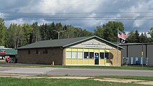
 Police department and city hall
 -
 U.S. Post Office in Beaverton
 -
 County branch library in Beaverton


.jpg)
Notable people[edit]
- Homer Bliss (1904–1970), professional American football player
References[edit]
- ^ City of Beaverton (2021). "City of Beaverton: City Hall". Retrieved September 4, 2021.
- ^ "2020 U.S. Gazetteer Files". United States Census Bureau. Retrieved May 21, 2022.
- ^ a b "U.S. Census website". United States Census Bureau. Retrieved 2008-01-31.
- ^ U.S. Geological Survey Geographic Names Information System: Beaverton, Michigan
- ^ "Explore Census Data". data.census.gov. Retrieved 2023-10-07.
- ^ Romig. Michigan Place Names.
- ^ "2019 U.S. Gazetteer Files". United States Census Bureau. Retrieved July 25, 2020.
- ^ Climate Summary for Beaverton, Michigan
- ^ "Census of Population and Housing". Census.gov. Retrieved June 4, 2015.
- ^ "U.S. Census website". United States Census Bureau. Retrieved 2012-11-25.
Further reading[edit]
- Romig, Walter, L.H.D. Michigan Place Names. Detroit: Wayne State University Press, 1986.
- Powers, Perry Francis. A History of Northern Michigan and Its People. Chicago: Lewis Publishing Co., 1912. [1] [2] [3]
- Frei, Robert W. and the Beaverton Centennial Committee. Beaverton: A Century in the Making. Beaverton: Beaverton Centennial Committee, 2003
External links[edit]
Municipalities and communities of Gladwin County, Michigan, United States | ||
|---|---|---|
| Cities |  | |
| Civil townships | ||
| Unincorporated communities | ||
| Ghost town | ||
| International | |
|---|---|
| National | |