
Baker River (Chile)
| Baker River | |
|---|---|
 | |
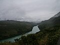
Baker River in the Aysén Region | |
| Location | |
| Countries | |
| Physical characteristics | |
| Source | |
| • location | Bertrand Lake |
| • elevation | 200 m (660 ft)[1] |
| Mouth | |
• location | Baker Channel, Pacific Ocean |
| Length | 170 km (110 mi)[1] |
| Basin size | 26,726 km2 (10,319 sq mi)[1] |
| Discharge | |
| • average | 875 m3/s (30,900 cu ft/s)[2] |
The Baker River is a river located in the Aysén del General Carlos Ibáñez del Campo Region of the Chilean Patagonia. It is Chile's largest river in terms of volume of water. The river flows out of Bertrand Lake, which is fed by General Carrera Lake. It runs along the east side of the Northern Patagonian Ice Field and empties into the Pacific Ocean, near the town of Caleta Tortel. The river forms a delta, dividing into two major arms, of which only the northernmost one is navigable.
Its characteristic turquoise-blue color is due to the glacial sediments deposited in it.
It was the proposed site of a controversial major hydro-electric project, involving five dams, to be the biggest in the history of Chile. Called HidroAysén, the project was a joint venture between Endesa Chile a subsidiary of the international energy conglomerate Enel, and Colbún S.A. a subsidiary of Minera Valparaíso. The series of hydro-electric dams were proposed along both the Baker and Pascua rivers, two of Chile's mightiest rivers. The project was opposed by a protest campaign led by Chilean and international environmental activist groups. Few rivers this large in the world remain undammed and free flowing.[3] Chile's Committee of Ministers overturned the environmental permits for the HidroAysén dam project June 2014.[4][5]
Tributaries[edit]
The river also receives the waters of the Cochrane Lake through the Cochrane River. Other major tributaries are:
- Nef River
- Chacabuco River
- Del Salto River
- Colonia River
- De los Ñadis River
- Ventisquero River
- Vargas River
Gallery[edit]
-
 Kayaking is a popular sport on the river.
 -
 Winter 2006


See also[edit]
| Rivers | .png) | |
|---|---|---|
| Lakes | ||
| Glaciers | ||
References[edit]
- ^ a b c Río Baker Archived 2007-07-06 at the Wayback Machine
- ^ "Hidrografía Región de Aysén". Biblioteca del Congreso Nacional de Chile (in Spanish). Retrieved 2022-03-02.
- ^ "Resources - International Rivers".
- ^ "Chile Scraps Huge Patagonia Dam Project After Years of Controversy". Archived from the original on 2014-06-15.
- ^ "Chilean Patagonia spared from US$10 billion mega-dam project | David Hill". TheGuardian.com. 11 June 2014.
External links[edit]
- Hidrografía Región de Aysén, Sistema Integrado de Información Territorial
- Endesa Opponents Call Foul The Santiago Times
| International | |
|---|---|
| National | |
47°01′24″S 72°49′47″W / 47.02333°S 72.82972°W
This Aysén Region location article is a stub. You can help Wikipedia by expanding it. |
This article related to a river in Chile is a stub. You can help Wikipedia by expanding it. |