
BR-262 (Brazil highway)
 | |
|---|---|
 | |
| Route information | |
| Length | 2,295.4 km (1,426.3 mi) |
| Major junctions | |
| East end | Vitória, Espírito Santo |
| West end | Corumbá, Mato Grosso do Sul |
| Location | |
| Country | Brazil |
| Highway system | |
BR-262 is an east-west highway connecting the Brazilian states of Espírito Santo, Minas Gerais, São Paulo and Mato Grosso do Sul.[1][2][3]
The highway runs from Vitória state capital of Espírito Santo to the Bolivian border at Corumbá, Mato Grosso do Sul.[4][5]
Duplications[edit]
The 84 km stretch from Betim (MG) to Nova Serrana (MG) was doubled in 2011.[6]
The 180 km stretch between Viana (ES) and the border with Minas Gerais will be granted in 2020, and the duplication should occur by 2040. The stretch between Viana and the Victor Hugo district, in Marechal Floriano, must be duplicated by 2028. [7]
Economy[edit]
The highway is important for products from Brazilian agriculture, livestock, mining and industry. In the future, it will also act in conjunction with the Bioceanic Corridor, which connects Campo Grande-MS with the ports of northern Chile. At the other end, it reaches the coast of Espírito Santo. As some examples, the production of coffee from Minas Gerais, as well as iron ore from Minas Gerais to Espírito Santo, and soybeans and other grains and beef from Mato Grosso do Sul, all are largely transported by this highway. [8]
Tourism[edit]
The highway is of great tourist importance, especially for Espírito Santo, which receives a large flow of people from Minas Gerais to the beaches of Espírito Santo. [9]
In Mato Grosso do Sul, the road that runs along the Pantanal is also an important tourist route. [10] Together with the bi-oceanic corridor that will link Brazil with Paraguay, northern Argentina and northern Chile, the BR -262 will serve as a link to several tourist destinations: the Entrance of the Andes Mountains, in Jujuy, Argentina; the Atacama Desert, in Chile (which connects the most flooded area on the planet, the Pantanal, with the driest area on the planet); and even to the beaches of the Northeast. [11]
Gallery[edit]
-
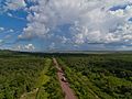 BR-262, about 50 km from Corumbá, Mato Grosso do Sul
 -
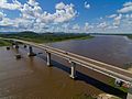 Poet Manoel de Barros bridge, in Corumbá, Mato Grosso do Sul
 -
 BR-262 in Mato Grosso do Sul
 -

-
 BR-262 in Luz, Minas Gerais
 -
 BR-262 near Bom Despacho, Minas Gerais
 -
 BR-262 in Manhuaçu, Minas Gerais
 -
 BR-262 in Ibatiba, Espírito Santo
 -
 BR-262 in Conceição do Castelo, Espírito Santo


.jpg)


References[edit]
- ^ Page of the National Department of Transport Infrastructure containing maps of all states in Brazil Archived 2010-01-31 at the Wayback Machine
- ^ "BR 262". Archived from the original on 2012-11-22. Retrieved 2013-04-08.
- ^ Rodovias Transversais
- ^ Page of the National Department of Transport Infrastructure containing maps of all states in Brazil Archived 2010-01-31 at the Wayback Machine
- ^ "BR 262". Archived from the original on 2012-11-22. Retrieved 2013-04-08.
- ^ Duplicação da BR-262/MG será entregue oito meses antes do prazo
- ^ Concessão da BR 262: pedágio em 2021 e duplicação completa em 2040
- ^ Rota de turistas, BR 262 e ES 010 causam prejuízo com buracos
- ^ Rota de turistas, BR 262 e ES 010 causam prejuízo com buracos
- ^ br-262-no-pantanal-cenario-de-encontros-entre-homens-e-animais-silvestres
- ^ "Brasil planeja estímulo ao turismo pelo Corredor Bioceânico". Archived from the original on 2020-02-23. Retrieved 2021-03-12.
| Radial highways (originating from Brasília) | |
|---|---|
| North-south highways | |
| East-west highways | |
| Diagonal highways | |
| Link highways |
|