
Auerbach (Vogtland)
Auerbach | |
|---|---|
 Church of Saint Lawrence in the center of Auerbach | |
 Coat of arms | |
Location of Auerbach (Vogtland) within Vogtlandkreis district  | |
 Auerbach  Auerbach | |
| Coordinates: 50°30′34″N 12°24′0″E / 50.50944°N 12.40000°E | |
| Country | Germany |
| State | Saxony |
| District | Vogtlandkreis |
| Subdivisions | 5 |
| Government | |
| • Mayor (2022–29) | Jens Scharff[1] (Ind.) |
| Area | |
| • Total | 55.52 km2 (21.44 sq mi) |
| Elevation | 555 m (1,821 ft) |
| Population (2022-12-31)[2] | |
| • Total | 17,759 |
| • Density | 320/km2 (830/sq mi) |
| Time zone | UTC+01:00 (CET) |
| • Summer (DST) | UTC+02:00 (CEST) |
| Postal codes | 08209 |
| Dialling codes | 03744 |
| Vehicle registration | V, AE, OVL, PL, RC |
| Website | www |
Auerbach (German pronunciation: [ˈaʊ.ɐbax] ⓘ) is a town in the Vogtlandkreis, Saxony, Germany. It is the regional centre of the eastern Vogtland. The economy is mainly based on textile manufacturing, food processing and machine industry. After Plauen and Reichenbach, Auerbach is the third most populous town in the Vogtlandkreis.
Auerbach was mentioned for the first time in 1282. The town is situated at the declivities above the river Göltzsch at the foot of a castle tower from the 12th century. Landmarks include the towers of the St. Laurentius church, the Catholic Zum Heiligen Kreuz church and the 43.9-metre-high (144 ft) tower of the castle. The three tall buildings give Auerbach its nickname “the Three Towers Town”.
Demographics[edit]
Historical population (from 1960, as on 31 December):
|
1834 to 1960
|
1971 to 2008
|
After 2012
|
Data source from 1998: Saxon State Statistical Office
1 29 October
2 31 August
-
 Auerbach Castle
 -
 Zum Heiligen Kreuz Church
 -
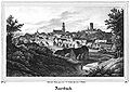 Auerbach, lithographie from a drawing by Carl Wilhelm Arldt, 1839


References[edit]
- ^ Gewählte Bürgermeisterinnen und Bürgermeister im Freistaat Sachsen, Stand: 17. Juli 2022, Statistisches Landesamt des Freistaates Sachsen.
- ^ "Einwohnerzahlen nach Gemeinden als Excel-Arbeitsmappe" (XLS) (in German). Statistisches Landesamt des Freistaates Sachsen. 2024.
External links[edit]
| International | |
|---|---|
| National | |
| Geographic | |
This Vogtlandkreis location article is a stub. You can help Wikipedia by expanding it. |