
Argolic Gulf
| Argolic Gulf | |
|---|---|
| Αργολικός κόλπος (Greek) | |
 The Argolic and Saronic Gulfs, separated by the Argolis peninsula | |
 Argolic Gulf Location of the Argolic Gulf within Greece | |
| Location | Peloponnese |
| Coordinates | 37°20′N 22°55′E / 37.333°N 22.917°E |
| Type | Gulf |
| Part of | Aegean Sea |
| Basin countries | Greece |
The Argolic Gulf (Greek: Αργολικός κόλπος, romanized: Argolikós kólpos), also known as the Gulf of Argolis, is a gulf of the Aegean Sea off the east coast of the Peloponnese, Greece. It is about 50 km long and 30 km wide. Its main port is Nafplio, at its northwestern end. At the entrance to the gulf is the island Spetses.[1] This gulf and its islands are sometimes combined with the Saronic Gulf and Saronic Islands, with the result called the Argo-Saronic Gulf and the Argo-Saronic Islands. It is surrounded by two regional units: Arcadia to the southwest and Argolis to the north and east. The river Inachos drains into the Argolic Gulf near Nea Kios. The main islands in the gulf are Psili, Plateia and Bourtzi, a small island with a Venetian fortress that protects the port of Nafplio. The surrounding mountains protect it from the strong summer Meltemi wind.
The main towns that lie around the gulf are, from southwest to east:
- Tyros
- Paralio Astros
- Myloi
- Nea Kios
- Nafplio
- Tolo or Tolon, on Tolo Bay
- Porto Cheli
- Spetses
Gallery[edit]
-
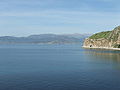
 Argolic Gulf - view from Tolo
 -
 The island and Apostolou Church
 -
 Argolic Gulf
 -
-
 Argolic Gulf - view from Nafplion
 -
 Bourtzi Tower
 -
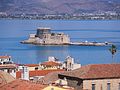 View of Nafplion, Bourtzi and Argolic Gulf
 -
 Sailboat on the Argolic Gulf near the harbour of Nafplio
 -


References[edit]
External links[edit]
 Media related to Argolic Gulf at Wikimedia Commons
| International | |
|---|---|
| National | |
| Geographic | |