Berlin-Charlottenburg station
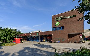
Berlin-Charlottenburg is a railway station in the Charlottenburg district of Berlin. The station is located on the Stadtbahn line, served by the S3, S5, S7, and S9 lines of the Berlin S-Bahn, as well as by Regional-Express and Regionalbahn trains operated by Deutsche Bahn. The U-Bahn station Wilmersdorfer Straße (U7) can be reached via short footpath.
History[edit]

The station was opened on 7 February 1882 as the western endpoint of the Stadtbahn line in the then independent town of Charlottenburg. From here the Berlin-Blankenheim railway ran southwestwards, a section of the Kanonenbahn rail route to Metz in Alsace-Lorraine.
The old station hall was damaged in World War II and only provisionally repaired afterwards. During the Cold War era parts of the track installations were reserved for the deployment of British Forces in Berlin. The station was the Berlin terminus for the British Military Train ("The Berliner") which carried allied military and diplomatic passengers across the GDR to Braunschweig in West Germany.[2]

When nearby Wilmersdorfer Straße was converted into a pedestrian zone, a new railway underpass was built at the site of the old station hall, which was then completely demolished and rebuilt, with the replacement opening on 6 July 1971. After the East German Deutsche Reichsbahn state railway passed the West Berlin S-Bahn network to the Berliner Verkehrsbetriebe (BVG) public transport company, Charlottenburg Station in the early morning of 9 January 1984 was the starting point of the first BVG operated train.
In 2003 the distance to the U-Bahn station Wilmersdorfer Straße was shortened by shifting the two S-Bahn platforms about 200 m (660 ft) further to the east and the opening of a new eastern entrance near the corner of the shopping street. In recent years the tracks have been equipped with noise barriers and the 1970s entrance building has been thermally refurbished.
Train services[edit]
The station is served by the following services:[3]
| Line | Route (main stops) |
|---|---|
| RE 1 | Magdeburg – Brandenburg – Potsdam – Berlin-Charlottenburg – Berlin Hbf – Erkner – Fürstenwalde – Frankfurt (Oder) (– Cottbus) |
| RE 2 | Nauen – Berlin-Charlottenburg – Berlin Hbf – Königs Wusterhausen – Lübben – Cottbus |
| RE 6 | Wittenberge – Perleberg – Pritzwalk – Neuruppin Rheinsberger Tor – Kremmen – Velten (Mark) – Hennigsdorf (b Berlin) – Falkensee – Berlin-Spandau – Berlin-Charlottenburg |
| RE 7 | Dessau – Bad Belzig – Michendorf – Berlin-Charlottenburg – Berlin Hbf – Berlin Brandenburg Airport – Wünsdorf-Waldstadt – Lübben (Spreewald) – Senftenberg |
| RE 8 | Wismar – Schwerin – Wittenberge – Nauen – Berlin-Spandau – Berlin-Charlottenburg – Berlin Hbf – Berlin Ostkreuz – BER Airport – Terminal 1-2 |
| RB 23 | Golm – Potsdam – Potsdam Griebnitzsee – Berlin-Wannsee – Berlin-Charlottenburg – Berlin Hbf – Berlin Ostkreuz – BER Airport – Terminal 1-2 |
| Spandau – Westkreuz – Berlin-Charlottenburg – Hauptbahnhof – Alexanderplatz – Ostbahnhof – Karlshorst – Köpenick – Erkner | |
| Westkreuz – Berlin-Charlottenburg – Hauptbahnhof – Alexanderplatz – Ostbahnhof – Lichtenberg – Strausberg Nord | |
| Potsdam – Wannsee – Westkreuz – Berlin-Charlottenburg – Hauptbahnhof – Alexanderplatz – Ostbahnhof – Lichtenberg – Ahrensfelde | |
| Spandau – Westkreuz – Berlin-Charlottenburg – Hauptbahnhof – Alexanderplatz – Ostbahnhof – Schöneweide – Berlin Brandenburg Airport |
References[edit]
- ^ "Der VBB-Tarif: Aufteilung des Verbundgebietes in Tarifwaben und Tarifbereiche" (PDF). Verkehrsbetrieb Potsdam. Verkehrsverbund Berlin-Brandenburg. 1 January 2017. Archived from the original (PDF) on 27 October 2020. Retrieved 26 November 2019.
- ^ British Military Train Card, retrieved 2007-11-09
- ^ Timetables for Berlin-Charlottenburg station (in German)


