
File:Residence Park development map, 1885 New Rochelle, New York.jpg

Size of this preview: 800 × 460 pixels. Other resolutions: 320 × 184 pixels | 640 × 368 pixels | 1,164 × 669 pixels.
Original file (1,164 × 669 pixels, file size: 366 KB, MIME type: image/jpeg)
Summary[edit]
| Description |
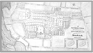
Image of 1885 development 'map' for the planned residential community "Residence Park" in New Rochelle, New York, USA. |
|---|---|
| Source |
Original publication: 1885, New Rochelle, NY |
| Date |
1885 |
| Author |
Adrian Iselin, Jr. |
| Permission (Reusing this file) |
Map created before development of the Residence Park community which occurred in 1885
|
Licensing[edit]
| This work is in the public domain in the United States because it was published (or registered with the U.S. Copyright Office) before January 1, 1929. |
File history
Click on a date/time to view the file as it appeared at that time.
| Date/Time | Thumbnail | Dimensions | User | Comment | |
|---|---|---|---|---|---|
| current | 10:42, 26 November 2014 | | 1,164 × 669 (366 KB) | WNBC2014 (talk | contribs) | Uploading an old public-domain work using File Upload Wizard |
You cannot overwrite this file.
File usage
The following pages on the English Wikipedia use this file (pages on other projects are not listed):